![]()
Nevada Northern & Railroads of White Pine County |
|
Giroux Consolidated Mines Company History The Giroux Group — Properties, Ore Deposits, and Mines |
||
|
Spencer, Arthur C. 1917. The Geology and Ore Deposits of Ely, Nevada. Professional Paper 96. Washington D.C.: United States Geological Survey, Department of the Interior, pp. 91-92, 94-98, 136-138, 142-143, 146, 148-149. |
||
|
These excerpts from Spencer's work are presented as an adjunct to the Giroux Consolidated Mines Company Railroad pages. Taken together, they present a history of the Giroux Consolidated Mines Company and a description of its properties, ore deposits, and mines until the 1913 merger that saw the Giroux company become part of the Consolidated Coppermines Co. |
||
|
Ore Deposits — Historical Notes |
||
|
Mining activity in eastern Nevada began in 1862, with the discovery of silver-bearing ore near the Overland Stage Route, at the present town of Austin, Lander County. In November, 18671, a company of men guided by an Indian named John, came south from Egan Canyon, making locations near Ice Creek (undoubtedly the same as Murry Creek), which led to the organization of the Robinson mining district on March 16, 1868. The district was named in honor of a member of the party, Thomas Robinson, who previously had been an assayer at Pahranagat. Mining activity throughout northern Nevada was greatly stimulated by the completion of the Central Pacific Railroad, which in 1869 effected a junction with the Union Pacific about 40 miles west of Ogden, Utah. Developments in the Robinson district were undoubtedly furthered by this event and early in 1870 the population of Mineral City numbered about 400. The removal of the county seat from Hamilton to Ely in 1886 seems to have aided in a renewal of interest in the district. During the summer of 1895 assessment work was done on the Star, Star of the West, Brooks, and Pilot Knob at "West Camp." These show large lodes of oxidized copper ores, mixed here and there with sulphides. ...the year 1898 was marked by the coming of Snedaker & Giroux, who took a bond on a property of 18 claims grouped about Pilot Knob, in the western part of the district. Ore was discovered on the Morris claim in April, 1899. The Pilot Knob group was bonded to agents of W. A. Clark (with whom Joseph Giroux had previously been associated), and a 20-horse power hoisting plant was installed on the Pilot Knob claim.2 In 1902 the workings of the Pilot Knob Copper Co. comprised four shafts, the deepest 300 feet. A body of low-grade ore was developed. The Giroux Consolidated Mining Co., which was organized during 1903, succeeded to the properties of the Pilot Knob Copper Co. and of the Florida Grande Co., operating in Mexico. The Giroux shaft, on Old Glory Hill, reached the depth of 450 feet and showed promising results. Low-grade ore bodies were blocked out on the Morris claim, and the Taylor and Dewey claims were prospected by shafts. Water rights were secured on Steptoe Creek. In 1904 the Giroux Co. let a contract for a 250-ton smelting plant. The Brooks and Bunker Hill and Alpha shafts were started. The owners of the Giroux properties continued development; a concentrator was completed and a blast furnace essentially finished in 1906. Ore was found on the 700-foot level of the Alpha mine and sinking was continued. |
||
|
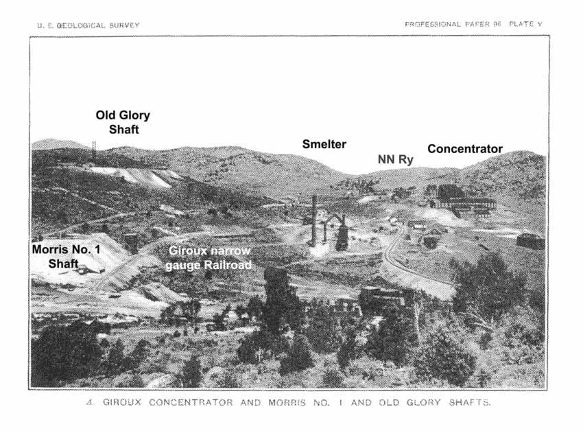
The years 1906 and 1907 were boom years in the district...the Giroux properties were systematically explored and ore bodies blocked out on the contiguous Morris Brooks and Bunker Hill claims. In April, 1907, a serious cave-in occurred in the Alpha shaft and several miners lost their lives. Three men were rescued after more than a month's imprisonment, during which time food was conveyed to them through a 6-inch pump line in the shaft. The Giroux concentrator was put into operation in September. (See Pl. V, A.) |
Giroux Consolidated Mines Co. |
|
In 1908 the Giroux property and that of the Butte & Ely Co. passed into the control of the so-called Cole-Ryan interests, and several adjacent properties were purchased. In 1913 the Consolidated Copper Mines Co. was formed for the purpose of consolidating the Giroux Consolidated Mining co., the Coppermines Co., the Ely Central Co., and the Chainman Consolidated Copper Co. |
|
|
Giroux Group — Location |
|
|
The property segregated by the Giroux Consolidated Mines Co., here called the Giroux group, consists of 100 claims and fractions aggregating nearly 2,000 acres. The group includes an area about 1,600 feet long and from 4,000 to 9,000 feet wide, situated between the Veteran group on the northwest and the Copper Flat and Ely-Central groups on the east. It lies partly within the broad basin that comprises Weary Flat and covers also the ridge between the Robinson and White River basins, together with the upper south and west facing slopes beyond this divide. Within the area on the north are the Taylor and Dewey shafts; in the west third the Pilot Knob, Old Glory, and Alpha shafts, and the Bunker-Morris mines; and in the eastern part the Oro open mine and the Tonopah and Westphalia ore bodies. The systematic development of the Giroux property was begun in 1900. In May of that year J. A. Snedaker and E. L. Giroux examined several groups of claims situated in the western part of the district and arranged for prospecting work to be done on the Pilot Knob and adjacent claims. In May, 1901, Mr. Joseph L. Giroux visited the district in company with Mr. Snedaker, and during the following summer a group of 33 contiguous claims came under the control of these engineers and their associates. In 1901 or 1902 the Pilot Knob Copper Co. was formed, and before the close of 1902 eight shafts from 85 to 330 feet deep had been sunk, nearly 3,000 feet of lateral work had been done, and copper deposits had been discovered in the Taylor, Pilot Knob, Old Glory, and Brooks workings. The Giroux Consolidated Mines Co. was organized in 1903, and the Pilot Knob group passed into its possession, together with the Morris group of claims. At this time the total area of the group was about 870 acres, but during the next six years several parcels of land were bought and in 1908 the area amounted to 1,050 acres. In the later part of 1908 the majority of the shares of the Giroux Co. were acquired by the Cole-Ryan interests. The new management made extensive purchases of contiguous lands situated west of the original group in 1909-10, and in 1910, through the purchase of a majority of the Butte & Ely Copper Co. shares, secured control of 210 acres lying between the Giroux and Copper Flat groups. In 1913 the Consolidated Copper Mines Co. was organized and in May of that year this company acquired a substantial majority of the outstanding shares of the Giroux Consolidated Mines Co. and took over its affairs. Previous to 1905 explorations under the presidency of Mr. Giroux had revealed disseminated chalcocite ores in the Bunker, Brooks, and Morris mines, and ores of higher grade in the Taylor and Old Glory mines, and on the basis of these developments the decision was made to install concentrating and smelting works. A 250-ton blast furnace, completed in May, 1907, was destroyed by fire in December, 1908, before it had been put into use. The concentrator, which had a rated capacity of 500 tons a day, was put into experimental operation in October, 1907. (See Pl. V, A, p. 96.) The ore treated came principally from the Morris porphyry mine. Early in 1906 the discovery of oxidized copper ores was announced on the 770-foot level of the Alpha mine, and during the following 18 months explorations were extended to the 1,000-foot level. In August, 1907, 210 cars of ore that carried between 12 and 14 per cent copper were mined from the 1,000-foot level and shipped to the Garfield smelter at Salt Lake City. On December 4, 1907, the Alpha shaft gave way above the 600-foot level and several miners were imprisoned on the 1,000-foot level during a period of 46 days. In May, 1908, the shaft repairs were completed and sinking was continued to a depth of 1,200 feet, where oxidized ores like those on the 1,000-foot level were found in November or December, 1908. The Giroux shaft, which was planned as a working shaft, was begun in 1909 and opened to a depth of 1,440 feet in 1911. Connections with the Alpha workings had been made on three levels, the Alpha 100-foot and 1,200-foot workings had been retimbered, and some new work had been done in the ore ground on these levels. On the 1,400-foot level a tunnel had also been opened for a distance of 420 feet in the direction of the Alpha shaft, when on August 23, 1911, the main shaft took fire at the 1,000-foot level. As a result of this disaster several lives were lost, and the workings were flooded. Though the mine was unwatered in February, 1912, little or no work was done in the way of further development, and on October 2, on account of a strike of the mine workers, the pumps were stopped and water again took possession of the workings below the 1,000-foot level. During the year 1913 the mine appears to have been again active as the shipment of 230 tons of ore that contained an average of 8.77 per cent copper is reported.3 The Butte & Ely Copper Co. was organized in 1905. Three shafts were sunk and on the Beehive and Westphalia claims some porphyry ore had been developed when the active operations of the parent company were suspended in 1907. Subsequent to 1909 explorations by the Giroux management were made by churn drilling, and porphyry ore that was developed on the Westphalia claim has been stripped by the Nevada Consolidated Co. in connection with its own operations on the adjoining Liberty claim. The bodies of porphyry ore in the Bunker-Morris group of mines had been explored by more than a mile of workings pervious to 1909, and at that time the estimate of the known minable porphyry ore was 4,000,000 tons of 2.25 per cent grade. Between 1909 and the end of 1911 explorations in the porphyry areas were carried on mainly by means of churn drills. In the annual report of the company for the year 1911 the aggregate porphyry ore tonnages then developed in four localities were estimated at nearly 10,000,000 tons of 2 per cent and more than 6,000,000 tons of 1.65 per cent ore. Later estimates are referred to on page 114. In 1911 a contract was made with the Steptoe Valley Mining and Smelting Co. for the treatment of concentrating ores in quantities as large as 1,200 tons a day, and between May 1 and the close of the year 1912 shipments from the Bunker-Morris mine amounted to 140,877 tons of 2.15 per cent ore. This mine continued to furnish its quota of 1,000 tons per day until September 1, 1913, when all mining underground was suspended. During 1913 a previously unknown ore body was discovered east of the Morris shaft, and stripping was reported in progress in November4 of that year. Perhaps the most striking incident in the history of the Giroux property was the discovery of the body of disseminated copper ore in the Oro claim. The Nevada Consolidated Co. had secured right of way through this claim, and in excavating for an approach to the Liberty pit the ore was encountered. The first shipment of about 1,100 tons of ore was made on August 19, 1913, and a steady production appears to have been maintained to the close of the year. Between May 1, 1912, and December 31, 1913, the production of copper from Giroux ores amounted to somewhat more than 9,000,000 pounds. |
|
|
The Mines |
|
|
Taylor Shaft The Taylor shaft is situated in the southern part of the Taylor claim, just beyond the northerly end of the porphyry area of the Goodenough and adjacent. The workings, which comprise a shaft said to be 300 feet deep and about 400 feet of laterals, were not accessible in 1909, or 1910. In the report of the Giroux Consolidated Mines Co. for the year ending December 31, 1912, the statement is made that during the year there was shipped from the Taylor dump 179.6 tons of ore that carried 0.10 ounce gold and 0.93 ounce silver to the ton, and 4.7 per cent copper.
The Old Glory shaft, formerly called the Giroux, is situated on the east slope of Old Glory Hill. (See Pl. V, A, p. 96.) The exploration of this ground was begun in 1900 and continued until 1906 or 1907. In 1910 the developed ore was estimated by the management of the Giroux Consolidated Mines Co. at 120,000 tons, and the average content at 3.5 per cent.
The Alpha Mine is situated about 7 miles west of Ely on the west side of the divide between Robinson Canyon and White River. The mine is served by a standard-gage track which connects with the mines branch of the Nevada Northern Railway. The output of the mine has been about 520 tons of ore that carried from 8 to 13 per cent of copper. |
 |
||
|
Spencer, Pl. VI, p. 112. Claim Map Showing Geology Along the Western Part of the Principal Zone of Intrusion and Metamorphism, Ely, Nevada |
|
Porphyry Ore Bodies of the Giroux Group |
||
|
Old Glory Hill The most westerly body of pyritized porphyry outcrops over an irregular area of about 15 acres, covering the summit and southwest slopes of Old Glory Hill. During 1910 the ground was explored by means of churn drills, 38 holes being put down to an average depth of 322 feet. As a result of the whole series of borings this section of the property was credited in the annual report of the company for the year 1910 with 650,000 tons of porphyry ore, whose mean copper content exceeded 1.6 per cent.
The most fully explored occurrences of porphyry ore on the Giroux property are those of the Bunker Hill, Brooks, Flying Dutchman, and Morris claims. Here in the connected workings known as the Bunker Hill and Morris mines two ore bodies were developed previous to 1909. In 1909 and 1910 this ground was explored by means of churn drills and in the annual report of the Giroux Consolidated Mines Co. for 1911 the developed ore was estimated at 4,010,000 tons or ore having a mean copper content of 2.14 per cent. An estimate6 made by Henry Krumb for the Consolidated Copper Mines Co. of the reserves in 1913 indicates 7,000,000 tons of 2 per cent ore. In these estimates the sulphide ore and also the carbonate ore, which occurs in the capping, are included. During the period between May 1, 1912, and September 1, 1913, the mine shipped about 250,000 tons of ore. The Bunker-Morris ore bodies prior to 1909 were developed by means of three shafts situated on the Morris, Brooks, and Bunker Hill claims. Morris No. 2 shaft, situated on the Brooks claim was constructed in 1909, and in 1912 three new openings to the surface were made.
Chalcocite-bearing porphyry was discovered by the Butte & Ely Copper Co. on its Beehive claim prior to 1907...but no details are available concerning the grades and tonnages of the ore developed by these explorations. Between the Beehive claim and the Nevada Northern Railway tracks on the Tonopah claim a body of chalcocite-bearing porphyry was developed by churn-drill explorations in 1910. In the annual report of the Giroux Consolidated Mines Co. for the year 1910 this ground was estimated to contain above 4,000,000 tons of ore that has a mean copper content of 1.11 per cent.
The Westphalia claim of the Butte & Ely Copper Co. covers the extreme west end of the porphyry intrusion that contains the great ore bodies developed in the Copper Flat and Liberty pits of the Nevada Consolidated Co. From the records of churn-drill explorations made by the Giroux Co. in 1909 it appears that enriched porphyry that carries as much as 1.5 per cent copper practically occurs only in the northeast corner of the Westphalia claim and the southeast corner of the Liberty Bell claim, though some ore of about this grade was found in the northeast corner of the Herstelle fraction. The amount of porphyry ore that has been developed in this locality would not justify independent mining operations. The reserves that exist will become available through the operations of the Nevada Consolidated Co., in the contiguous Liberty pit.
The Oro claim, the most easterly parcel of the Giroux property, is separated from the main group by the Josie claim, which belongs to the Nevada Consolidated Co. In 1910 a right of way over the Oro claim was granted to the Nevada Consolidated Co., and during the excavation of an approach to the Liberty steam-shovel pit in 1913 porphyry ore was discovered in the southern part of the claim. Though subsequent explorations are reported to have shown that this ore extends east and west upon the Nevada Consolidated property details in regard to the occurrence are not at hand. |
|
|
|
Footnotes |
||
|
1
White,
A. T., Nevada State Mineralogist Third Bienn. Rept., for 1869-70, pp.
86-87, 1871. |
||
|
|
Last modified 05 February, 2002 by Keith Albrandt |